There’s a certain irony in using one of the most modern social platforms on earth to find places that time forgot. But Instagram has quietly become one of the most powerful tools in an urban explorer’s or rural photographer’s arsenal — not because people post directions to these places, but because they post evidence that they exist. A single photograph of a crumbling grain elevator in central Montana, posted by someone who stumbled across it two years ago, is a breadcrumb that can lead you directly to your next shot. You just have to know how to follow it.
This two-part series breaks down a systematic approach to using Instagram as a location research tool — one that goes well beyond simply searching #abandoned.
Start With the Obvious Hashtags — Then Go Deeper
Every Instagram search begins somewhere, and for abandoned structure photography, the broad hashtags are your entry point, not your destination. Tags like #abandonedphotography, #abandonedplaces, and #urbex return millions of posts, which sounds useful until you realize you’re looking for a church in the Nebraska Sandhills, not a factory in Detroit.
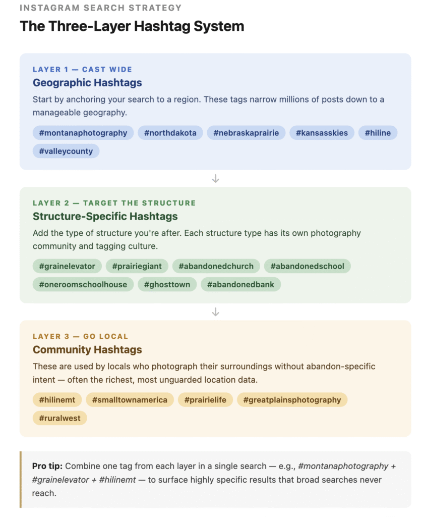
The real value comes from drilling down into geography-specific and structure-specific hashtags. Think in layers:
Geographic hashtags narrow your search to a region before you even think about the type of structure. Try combinations like #montanaphotography, #nebraskaprairie, #kansasskies, or #northdakota alongside abandoned-focused tags. Many rural photographers who aren’t explicitly “urban explorers” will tag their county or town by name — #valleycounty, #philippsburg, #hiline — giving you hyper-local results that broad searches never surface.
Structure-specific hashtags help you target the type of property you’re after. Grain elevators, for example, have their own dedicated tagging culture. Search #grainelevator, #grainelevators, #prairiegiant, #elevatorphotography, and #woodenelevator and you’ll find a dedicated community of photographers documenting these structures across the Great Plains. The same principle applies to other building types: #abandonedchurch, #abandonedschool, #abandonedbank, #oneroomschoolhouse, #ghosttown, and #abandonedgovernment all surface genuinely specific content.
Community-specific hashtags are often overlooked but are extraordinarily useful. Tags tied to regional identity — #hilinemt, #greatplainsphotography, #prairielife, #smalltownamerica — attract locals who photograph their surroundings without any particular interest in “abandonment photography.” These are often the most honest and location-rich posts because the photographer wasn’t trying to obscure where they were.
Geotags: The Hidden GPS System Inside Instagram
If hashtags are your net, geotags are your spearfishing gear. When a photographer tags a location on Instagram, they’re sometimes pinning an exact GPS coordinate — or at minimum, pointing to a named place that you can cross-reference on a map.
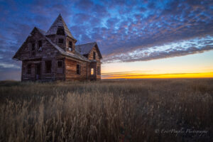
The workflow is straightforward. When you find a compelling image, tap the location tag at the top of the post. This opens Instagram’s location page for that place, which aggregates every public post tagged there. What you’ll often find is a collection of images from multiple photographers, across multiple years, all showing the same structure from different angles and in different seasons. This is a goldmine: not only do you now have confirmation the structure exists, you have a visual history of its condition over time.
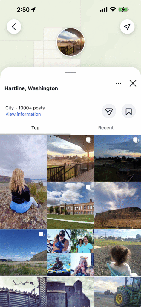
Many abandoned structures have been assigned informal Instagram location names by early posters — something like “Abandoned Church – Eastern Montana” or simply the name of the nearest ghost town. These informal tags then get used by subsequent visitors, creating an ever-growing album of the place. Search those informal location names directly in the Instagram search bar under the “Places” tab.
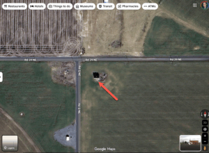
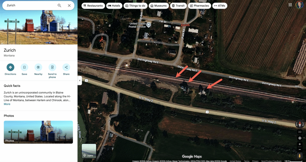
Pay attention to location tags even when they’re approximate. A post tagged to a small town with a population of 80 in rural Saskatchewan is already narrowing your search area to a few square miles. Combined with the image itself — noting the road type, vegetation, horizon line, or any visible signage — you often have enough to locate the exact property in Google Maps satellite view within minutes.
Reading the Image for Clues
Not every post will have a geotag, but that doesn’t mean the location is hidden. Skilled location research means learning to read the photograph itself as a document.
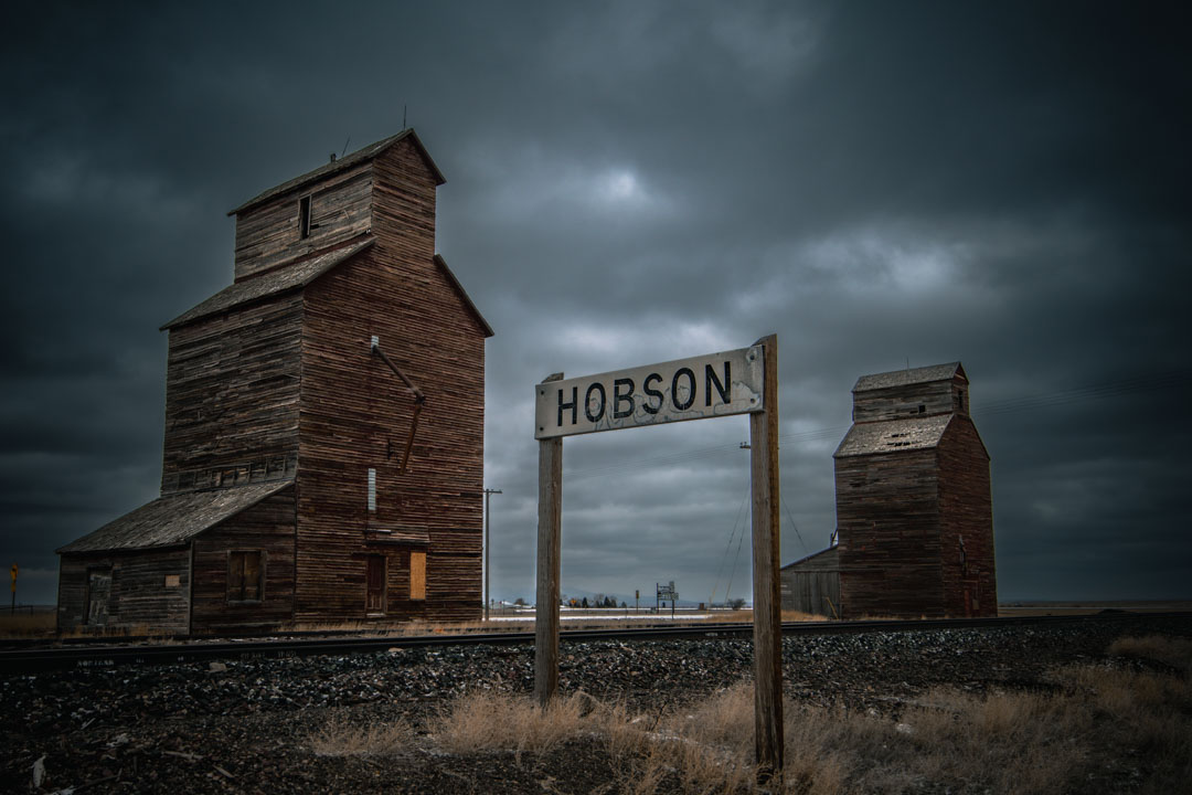
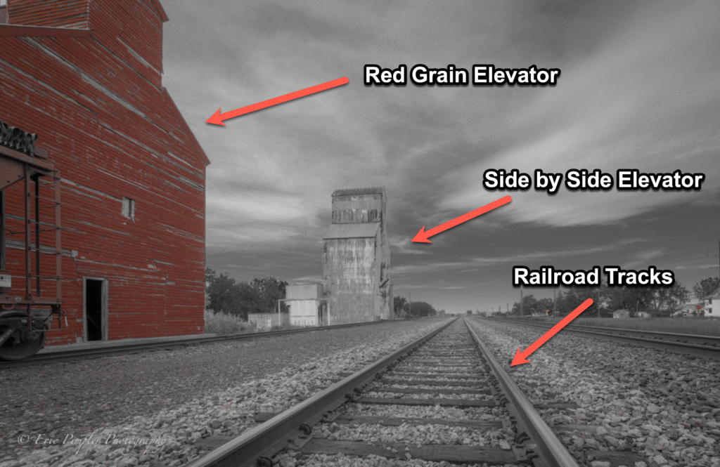
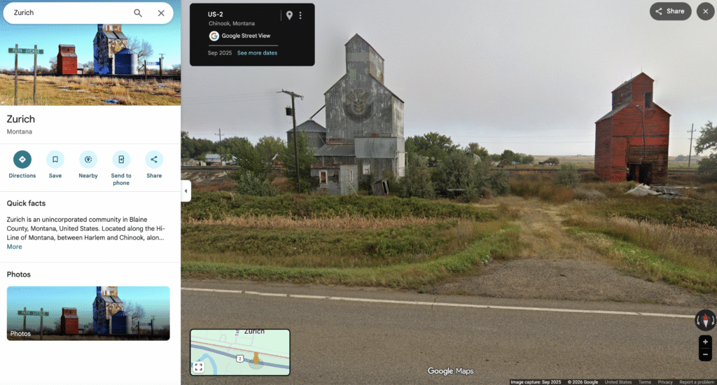
For rural structures specifically, the landscape tells you a great deal. The presence of a grain elevator typically means a railroad siding — search the rail lines in your target region and you can often match the visual profile of the elevator to the town it served. Abandoned churches and one-room schools tend to cluster along section line roads, and the surrounding topography — whether it’s the rolling Palouse, the flat shortgrass prairie, or the breaks country of eastern Montana — helps you narrow the geography significantly.
Look at the image metadata visible in the post: the account that posted it, who they follow, who commented. A commenter asking “where is this?” might have received a DM response, but more likely, another commenter provided a vague clue — “somewhere out on Highway 2” or “between X and Y.” These conversational crumbs in comment sections are easy to miss but frequently useful.
Also note the account’s broader posting history. A photographer who posts regularly from eastern Colorado and includes this abandoned bank in their feed almost certainly found it within driving distance of their home base. That narrows your search to a few counties.
Building a Working List
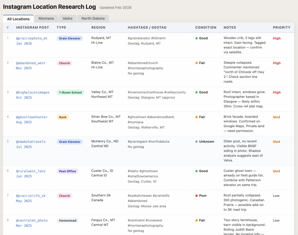
As you search, resist the temptation to try to pin down every location immediately. Instead, build a working research list — a simple spreadsheet or note document where you log the Instagram post URL, the structure type, the approximate geographic region, any hashtags or geotags present, and the condition of the structure based on the image. Over time, this list becomes a research database you can return to when planning a field trip to a specific region.
Cross-reference your Instagram finds against other sources. Google Maps satellite view is indispensable here — I covered my full five-step workflow for using Street View reconnaissance, shadow-reading in satellite view, and following railroad lines in Finding Abandoned Structures with Google Maps, and it pairs directly with what Instagram turns up. Flickr is another natural companion — its geotagged photo pools and group archives function similarly to Instagram’s location pages but with a longer historical record; I break that workflow down in Using Flickr to Find Abandoned Locations. Round those out with county plat maps (many of which are now publicly accessible online), the USGS historical topographic map archive, and newspaper archives. Instagram tells you a structure exists. These other tools tell you where it is, what it was, and whether it’s still standing.
In Part 2, we’ll move beyond passive searching into active strategies — building relationships with the Instagram photography community, leveraging Stories and Reels for real-time discovery, using Instagram’s geographic search in combination with Google Earth, and navigating the ethics and legal considerations of accessing abandoned properties responsibly.