In Part 1, we covered the foundational Instagram search techniques — hashtags, geotags, and reading images for geographic clues. That approach will surface thousands of abandoned structures you didn’t know existed. But if your goal is to find places that haven’t already been photographed to death, or to build a reliable pipeline of new locations before a field trip, you need a more active strategy. Part 2 is about going beyond the search bar.
Follow the Right Accounts — Then Follow Who They Follow
The most efficient thing you can do on Instagram as a location researcher is identify the 15 to 20 accounts that are most active in your target region and follow them closely. These are typically photographers based in the region, local historians who document rural heritage, county historical societies that maintain an Instagram presence, and rural lifestyle accounts that photograph the landscape as a byproduct of daily life.

Once you’ve identified these accounts, go deeper: look at who they follow and who they interact with in comments. The abandoned places photography community is tightly networked. The person photographing grain elevators in North Dakota almost certainly knows — either online or in person — the person photographing one-room schools in Saskatchewan. Following these second- and third-degree connections opens up an entirely new layer of content that the broad hashtag searches never reach.
Pay special attention to accounts that tag other accounts in their posts. A caption like “Thanks to @[localhistorian] for pointing me toward this gem” is explicitly telling you that there’s a local knowledge network operating in the background. Engaging with that historian’s account — even just following them and genuinely interacting with their content — can eventually open doors to location tips that aren’t publicly posted anywhere.
Use Instagram Stories and Reels for Real-Time Discovery
When you type a search term into Instagram, the results page offers five filter tabs along the top: For You, Accounts, Audio, Tags, and Places. For abandoned structure research, Tags and Places are the two you’ll use constantly — and most people never switch off the default view.

The Tags filter shows you every post associated with a hashtag, which is your primary search tool as covered in Part 1. But switching to the Places filter is where things get interesting for location research. Search the name of a small rural town — “Rudyard MT” or “Wheatland County” — and Places surfaces every post that has been geographically tagged to that location. This is a fundamentally different result set than a hashtag search. You’re not relying on a photographer having used the right hashtag — you’re pulling every post anyone has pinned to that geography, regardless of how they tagged it. A local rancher who posted a single photo of an elevator he drives past every day, tagged to his town but with no abandoned-specific hashtags at all, will show up here and nowhere else.
Use the Accounts filter to find regional photographers and historical societies worth following — search a county name or town and see which accounts are actively posting from that area. That’s your shortlist for the network-building strategy covered in the previous section.
The “Tagged Location + Satellite View” Workflow
This is the most reliable method for converting an Instagram discovery into a confirmed GPS coordinate. Here’s the full workflow:
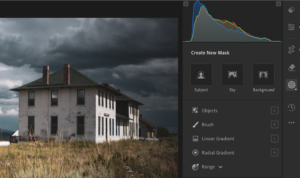
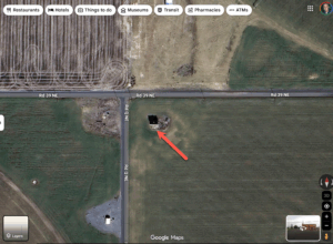
When you find a post with a location tag, open that location page and look at the map preview Instagram provides. It’s usually imprecise — often just pointing to the nearest town — but combined with the image itself, it gives you a search zone. Take that zone to Google Earth (not just Google Maps — the 3D terrain and historical imagery features in Google Earth are invaluable for this work). If you haven’t already built a Google Maps scouting workflow, my guide to Finding Abandoned Structures with Google Maps covers exactly how to read elevator shadows in satellite view, trace railroad sidings, and use the search box and user photo tabs to confirm locations before you ever leave the house — all of which complement what Instagram surfaces.
In Google Earth, activate the historical imagery slider and work backward through the years. Structures that have collapsed or been demolished will appear in older imagery but not newer — which helps you confirm whether a structure you found on Instagram from five years ago is still worth the drive. Structures that are partially obscured by vegetation in summer can sometimes be spotted more clearly in early spring or late fall imagery when the canopy is thinner.
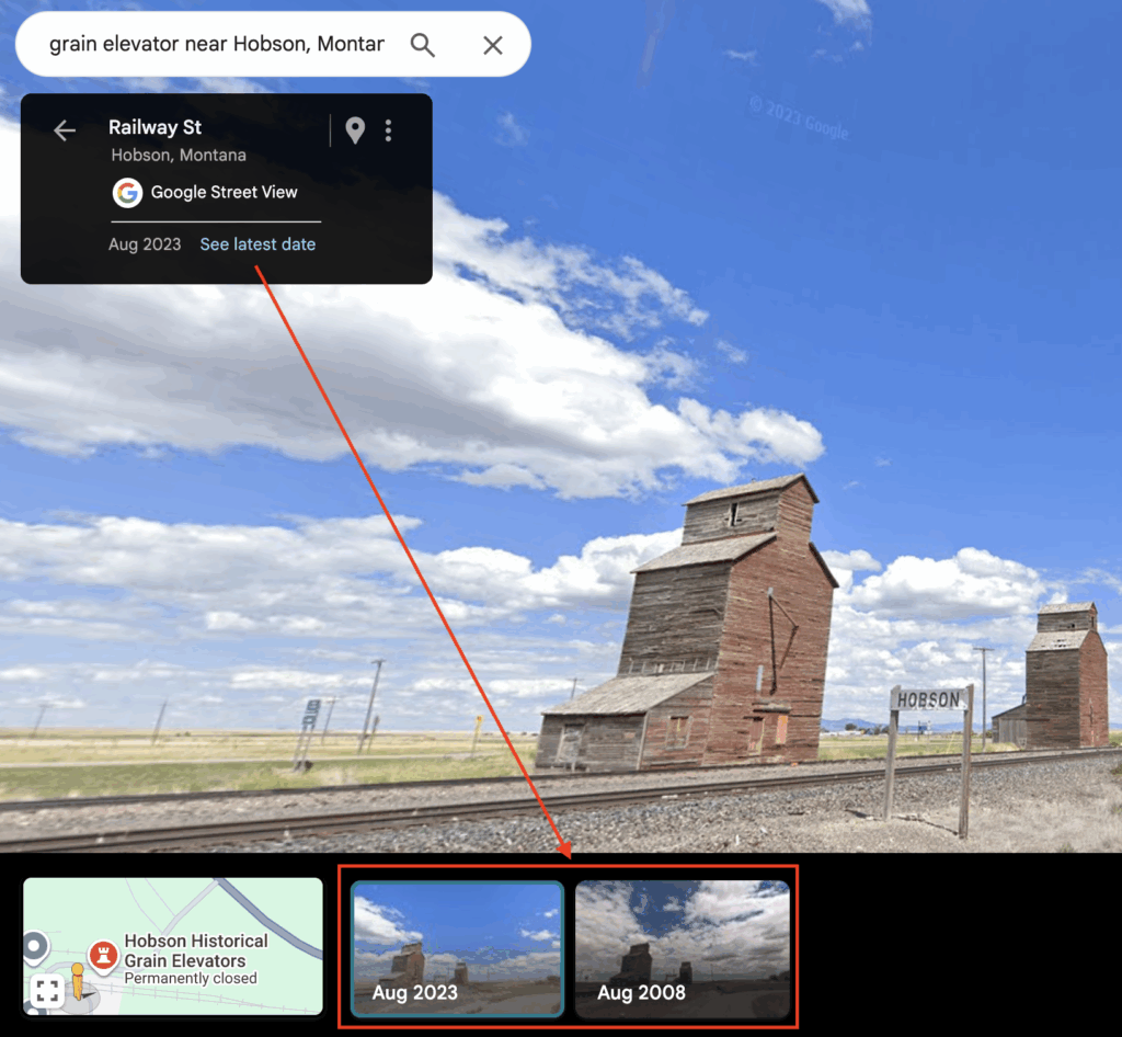
For grain elevators specifically, the combination of a railroad right-of-way visible in satellite imagery and the characteristic footprint of a wooden crib elevator makes them relatively easy to spot even without a precise geotag. Work along the rail lines in your target region and use the satellite view to identify likely candidates, then cross-reference with Instagram to see if any have been documented.
Targeting Specific Structure Types
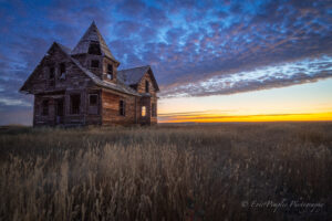
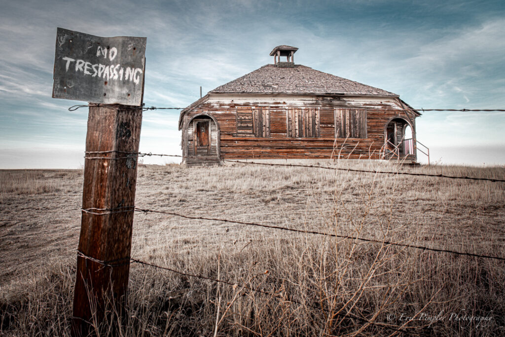
Churches and schools tend to cluster in areas of failed homestead settlement — places where population surged in the early 20th century and then collapsed. The Montana Hi-Line, the Oklahoma and Texas Panhandles, the Dust Bowl counties of Kansas and Colorado, and the central Nebraska Sandhills are all high-density areas for these structures. Search Instagram hashtags specific to these regions alongside #abandonedchurch and #oneroomschool. County historical societies in these regions often maintain Instagram accounts and will post images of structures that no commercial photographer has yet visited.
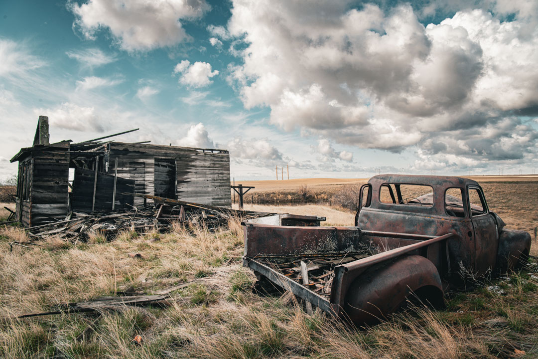
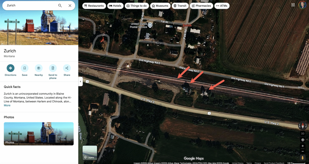
Grain elevators require a railroad-focused search strategy. The closure of hundreds of branch rail lines across the Great Plains between the 1970s and 1990s left a trail of elevator towns that were essentially abandoned overnight when the rail service ended. The Great Plains Trail Network and various railroad historical societies document these closed lines, and cross-referencing their maps with Instagram’s geographic search will point you toward towns that still have standing elevators but have received little photographic attention.
Banks and government buildings are most common in the ghost towns of the Mountain West — the silver and gold mining country of Montana, Idaho, Colorado, and Nevada. Search #ghosttown combined with specific state tags. The Nevada ghost town circuit in particular has a rich Instagram documentation history, but many Montana and Idaho mining towns remain photographically underexplored.
Finding Places No One Has Photographed Yet
This is the holy grail for any serious photographer of abandoned structures, and Instagram can actually help you identify these locations through a process of elimination. If a location appears in exactly zero Instagram posts, it either doesn’t exist, has already been demolished, or hasn’t been found yet. The third category is where opportunity lives.
Your best sources for undocumented locations are the county plat maps and rural atlas books published in the early-to-mid 20th century. These maps show every town, every school district, and every rural community that existed at a given moment in history. Many of these communities are gone today, but the physical structures that served them — a school, a church, a grain warehouse — sometimes survive on private land, invisible to the road and unrecorded on any modern map.
It’s also worth running your candidate locations through Flickr before you make the drive. Flickr’s geotagged photo pools and group archives go back further than Instagram’s — some groups dedicated to grain elevators, ghost towns, or specific states have been actively curated for fifteen-plus years. A structure with zero Instagram presence might have a dozen Flickr images from 2011, which tells you it existed then and gives you an approximate location to cross-reference. I cover that full workflow in Using Flickr to Find Abandoned Locations.
Cross-reference the place names from historical plat maps against Instagram’s place search. If a community named “Antelope” appears on a 1930 Montana atlas but returns zero Instagram results for “Antelope MT abandoned,” you have a research lead worth pursuing. Pair that with satellite imagery to look for structural footprints, and a call to the county historical society to ask whether anything survives.
Etiquette, Ethics, and Legal Considerations
No article on finding and photographing abandoned structures is complete without an honest discussion of access. The vast majority of abandoned structures in rural areas sit on private land. The romantic image of pulling over on a gravel road and walking up to a derelict church for an hour of photography obscures the fact that you are almost always on someone’s property.
The right approach, always, is to seek permission. In rural areas, landowners are often surprisingly willing to grant access when asked respectfully — especially if you explain that you’re a photographer documenting historical structures, and especially if you offer to share your images with them. Many a fence gate has been opened by a simple knock on the farmhouse door a half-mile down the road.
When using Instagram for research, respect the community norm of not sharing precise coordinates publicly. Many photographers in this space deliberately avoid geotags or use imprecise location names to protect structures from vandalism and careless visitors. When someone sends you a location tip privately, treat that information with the same discretion.
Finally, document what you find. The structures you photograph today are often gone within a decade. Your images — shared with historical societies, county museums, and the communities whose families built these buildings — become part of the historical record. That transforms your photography from a hobby into something genuinely worth doing.
Instagram is a tool, not the destination. The best location research combines digital discovery with old maps, satellite imagery, local knowledge, and the willingness to drive down a road you’ve never been down before to see what’s at the end of it.