There’s a particular kind of frustration that every abandoned structure photographer knows — the kind that hits when you’ve driven two hours down a state highway, turned onto a gravel road, followed it another twenty miles into the middle of nowhere, and arrived to find a concrete foundation, a few scattered bricks, and nothing else. The place is gone. It was gone before you left the house. You just didn’t know it yet.
I almost made that exact mistake in Colorado.
The Plan
I had two locations on my list for a shoot in eastern Colorado — the Peace Valley School and the Antelope Springs Church, both sitting in the same general area and worth combining into a single day trip. On paper it was a perfect itinerary: two distinct structure types, close enough together to hit in one run, and both with enough photographic documentation online to suggest they were worth the drive. I’d done my initial research, I had rough coordinates, and I was ready to go.
Before I finalized anything, I did what I always do before committing to a long drive — I went back to Flickr for one more pass through the photos.
The Last Photo in the Pool
Flickr’s group pools and individual photo streams have a depth that Instagram simply can’t match for older structures. Some of these pools have been accumulating images for fifteen or more years, which means you’re not just seeing what a place looks like today — you’re seeing its entire documented history in one place. I’ve found structures on Flickr that have no Instagram presence whatsoever, documented by photographers who were shooting film and uploading scans before Instagram existed.
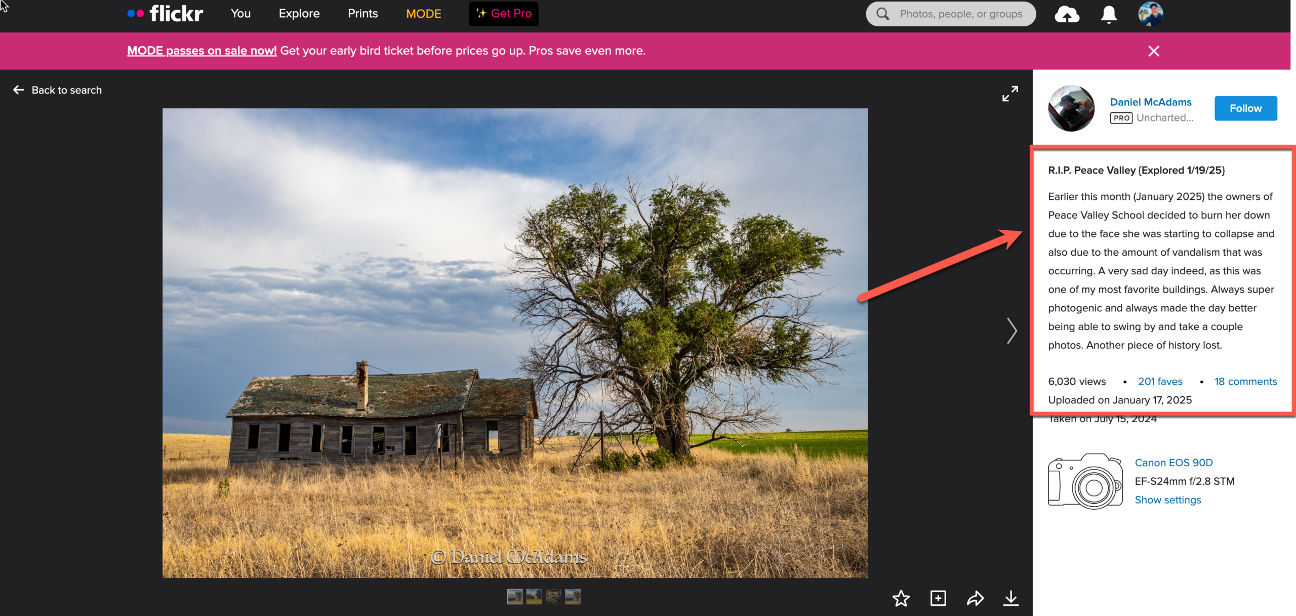
For the Peace Valley School, there were a good number of photos — enough to confirm it had been a real, photogenic location that other photographers had made the trip for. I worked through them, noting the condition across different years, the best angles, the light. Good bones. Worth the drive.
And then I got to the last photo in the results.
The caption was brief and matter-of-fact: the owners had burned the school down themselves. It had become structurally unsafe — a liability — and rather than let it collapse on its own, they’d made the decision to take it down deliberately. The photo showed what was left. There wasn’t much.
Four Hours
I pulled up a map and checked the drive time. Four hours, round trip, plus whatever time I would have spent on-site waiting for a structure that no longer existed. That’s a conservative estimate — in my experience, the “on-site” portion of a failed location scout includes a period of standing in an empty field trying to convince yourself you’re in the wrong spot, followed by a slow drive back down the gravel road replaying every decision that led you there.
Flickr saved me all of it. One caption. Thirty seconds of reading.
The Antelope Springs Church was still on the list — I confirmed it was standing and adjusted my plans accordingly. But the Peace Valley School came off the route entirely, and the day was better for it.
Why This Keeps Happening
Abandoned structures don’t last forever, and the rate of attrition is faster than most people outside this photography community realize. Structures are lost to fire — accidental and deliberate — to collapse, to demolition by landowners managing liability, to salvagers stripping the materials, and simply to the slow work of weather and time. A location that was standing and photogenic when it was first posted on Flickr or Instagram may be gone or unrecognizable within a few years.
The Peace Valley School situation is particularly common: landowners burning or demolishing structures that have become safety hazards. It’s a rational decision from their perspective, and there’s often no public record of it happening. No news item, no update on a historical society website. The only record is sometimes a single Flickr caption from a photographer who showed up to find the same empty field you would have found.
This is why a final verification pass — specifically on Flickr, where the photo history runs deepest — is a non-negotiable step in my pre-trip research workflow.
Building Verification Into Your Workflow
The instinct when you’ve found a compelling location is to lock in the coordinates and start planning the drive. Resist that instinct long enough to do one more check. Here’s how I approach it:
Search the location name on Flickr directly. Not just the structure type or the county — the actual name of the structure if it has one, plus the state. “Peace Valley School Colorado,” “Antelope Springs Church,” whatever the place is known as. You’re looking for the most recent photos, and more importantly, you’re reading the captions and comments on those recent photos carefully. Photographers who visit a site that’s been recently demolished often post what they found, exactly as I described above. That information is there if you look for it.
Check the photo dates, not just the photos. A beautiful image of a standing structure means nothing if it was posted in 2014 and nothing has been posted since. A gap in recent documentation is itself a warning sign — it might mean the location has become inaccessible, has been demolished, or simply isn’t worth photographing anymore. Recent activity, on the other hand, is a strong positive signal.
Read the comments. Captions tell you what the photographer saw. Comments tell you what other photographers have seen since. A comment from eight months ago saying “I drove out there last fall and the roof had caved in” is the kind of update that saves a wasted day.
Cross-reference with Google Maps Street View. As I covered in my guide to Finding Abandoned Structures with Google Maps, the Street View date stamp tells you when imagery was last captured for that road. If the most recent Street View shows the structure standing but that imagery is from 2019, you have a gap you need to account for. If Street View has never covered the road at all, Flickr’s photo history becomes even more important.
Use Instagram as a final real-time check. Search the location name in Instagram’s Places tab — as I covered in Using Instagram to Find Forgotten Places — to see if anyone has posted from that location recently. Instagram’s photo history is shallower than Flickr’s, but its recency is an asset. A post from three months ago showing a structure standing is meaningful confirmation.
The Structures That Are Already Gone
There’s a bittersweet dimension to all of this that’s worth sitting with for a moment. Every abandoned structure you photograph is already in the process of disappearing. Some will be gone within a year of your visit. Some were gone before you ever found them.
The Peace Valley School is one of those. I never photographed it. I never stood in front of it with a camera. By the time I found it in my research, it had already been reduced to ash by a landowner who had no obligation to preserve it for photographers who might want to visit someday.
That reality is part of what makes this kind of photography feel urgent. It’s also what makes the research matter. Every hour you spend verifying locations before you drive is time you’re not spending on a gravel road heading toward nothing — and time you could be spending in front of a structure that’s still standing, still worth photographing, and won’t be there forever.
Flickr gave me that hour back in Colorado. I used it on the Antelope Springs Church instead.
Before every field trip, run your locations through Flickr one more time. Read the captions. Check the dates. It takes twenty minutes and it has saved me more wasted drives than I can count.